
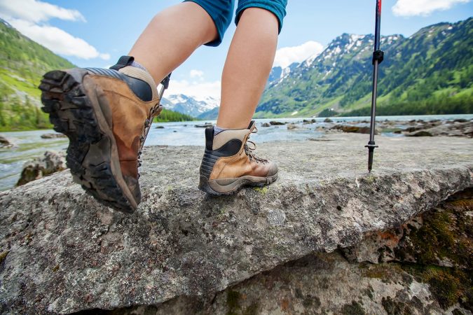
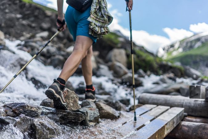
Spending time in nature, admiring the beauty around you is a dream. Getting lost in nature is a nightmare. Garmin is leading the charge to keep you on the trail by producing many of the best handheld GPS units on the market. This buying guide will tell you what to look for when you’re shopping for a handheld GPS, as well as review some of the best choices.
Quick Answer: The Best Handheld GPS
- Best Overall: Garmin GPSMAP 64sx
- Best Budget: Garmin eTrex 22x
- Best Hybrid: Garmin inReach Explorer+
- Best for Geocaching: Garmin eTrex 10
- Best Touchscreen: Garmin Oregon 700
What to Look for in a Good Handheld GPS
When buying a handheld global positioning system (GPS) there are several different things to keep in mind.
1. Design
One of the main things to consider is your preference for the design of the GPS. Do you want it to have buttons or a touchscreen? Think about what will be most practical for you.
- Touchscreen: GPS units with touchscreens are favored by some because of their quick response time and because they allow for a larger screen without larger dimensions. They also tend to be more intuitive. However, if you’re using GPS in winter weather conditions it can freeze, and in wet conditions you may have trouble with the screen. Plus touchscreen GPS consume more battery life at a quicker rate.
- Buttons: GPS units with buttons are slower and bulkier than touchscreen models, however they do have some pros. The battery will last longer and they’re more reliable in extreme temperatures. If you’re wearing gloves on a hike then you can still use the GPS with buttons.
2. Display
Most people appreciate larger screens, however this will decrease the portability and battery life of the GPS. While they’re all portable and you can travel with them no problem, the best GPS handhelds still vary widely in screen size. You can find screen sizes smaller than 3 inches and larger than 7 inches. Resolution is almost as important as screen size. The higher the resolution, the better the detail.
Consider what you’ll be doing most with the GPS. The best hunting handheld GPS options have a larger screen while backpackers will likely be alright using a GPS with a smaller screen. Be sure the screen has a backlight so you can read it at night and that it’s anti-glare so you can read it when the sun’s shining.
3. Battery
Some GPS models use AA batteries, while others use AAA batteries or rechargeable battery packs. Be sure the battery life is longer than your adventure. If not, be sure you have extra batteries or a portable charger to recharge the batteries on the go.
4. Receiver Type
All GPS units have a standard GPS receiver that includes a network of U.S.-owned satellites. However, there are some additional receivers that can add convenience when you’re traveling.
If the device has multi-GNSS support then it’s able to receive satellite signals broadcasted from multiple satellite systems. The increased number of satellites improves accuracy by receiving more satellite signals even in challenging environments like forests and canyons.
- Galileo: With Galileo, your position is provided by an independent European-owned satellite network. This is GPS in Europe.
- Wide Area Augmentation System: Referred to as WAAS, this system currently only works in North America. WAAS corrects data errors received from GPS satellites and gives you an accurate location within 3 meters, 95% of the time, as opposed to the standard 10-meter accuracy offered by most GPS units.
- EGNOS: EGNOS is similar to WAAS but was developed in Europe to improve location accuracy and correct position errors.
- GLONASS: If you get a device with GLONASS, you can pinpoint your location about 20% faster than with a typical GPS. This improves performance when you’re surrounded by dense trees or in a deep canyon thanks to additional satellites. This is a positioning system that was developed by the Russian Federation to prevent them from having to depend on U.S. satellites. You need to enable this system on your GPS but it will drain your battery quicker.
- Iridium®: You’ll want Iridium® if data communication, voice, and S.O.S. features are important to you.
5. Size & Weight
The size of the best handheld GPS for hikers might not be the same as it would be for someone who wants to take it with them on a boat or a bike. Consider just how portable you want your GPS to be and the features you want it to have. The more features, the larger the GPS will be. The unit itself won’t be super heavy but if you keep a lot of accessories or gear in your backpack, the weight can easily add up.
6. Reception
Most of the newer GPS models can narrow down your exact position with 10 meters. If you purchase a Garmin GPS equipped with WAAS then you’ll get a location reading that’s accurate to 3 meters or less. Tall trees and valleys can make a GPS signal less accurate. GPS units with the best reception utilize Galileo, GLONASS, GPS, and WAAS.
7. Memory for Maps
Many GPS units have preloaded basic maps. If you think you’ll want to download more maps or imagery then be sure the device has enough memory to hold them, or you can add an external SD card.
8. BirdsEye Satellite Imagery
This paid service allows you to see your destination in high-resolution color before you arrive. If you want detailed information about a campsite or want to do more specific route planning, you’ll appreciate this feature.
9. Wireless Capability
Some portable GPS units were created with Bluetooth technology. It’s particularly helpful if you’re traveling with others or if you want to share your route. You can also sync your smartphone to get messages and updates on your GPS.
10. HotFix® Capability
This feature helps your GPS pinpoint your location quicker. Built into some Garmin devices, after 30 minutes of use it will gather information about satellites it has a fix on and predicts where they’ll be up to 3 days later. So if you turn your GPS off for a day or so, your GPS will still retain some location data.
11. Compass
At some point in your adventure you may want to hold your GPS in the air to try to get a better signal. A standard compass won’t allow you to do that because they must be held horizontally to get the proper orientation. A differential compass must be in motion for it to work. A GPS with an electronic compass can read the direction regardless of how you’re holding the device. An electronic compass is typically favored because it’s the easiest, quickest, and most convenient of them all.
12. Barometric Altimeter
If your GPS has a barometric altimeter it will use changes in air pressure to determine your elevation. A great advantage to this feature is weather tracking. If you see a pressure increase then you can expect favorable weather. If the pressure plummets then it’s time to grab your portable umbrella or rain jacket and head for cover.
13. Media
Depending on your travel style, having a GPS with a voice recorder, camera, and / or photo viewer can make your trips more convenient. Lots of nature guides appreciate these features. These allow you to mark a waypoint instead of having to type it and taking photos decreases the chances of you accidentally wandering off the trail.
14. Geocaching
Geocaching is basically treasure hunting via GPS. You’ll use your GPS to find the hidden prize in a certain location. GPS units preloaded with geocaches allow players to forego paper maps.
15. Waypoints
Waypoints are points of references for navigation and location. These can be a landmark or a latitude and longitude of a location. You can delete waypoints after a hike, but if you’d prefer to keep waypoints from several of your trips then be mindful of how many your GPS can accommodate.
16. Waterproofing
If you’re going to be on the trail for an extended amount of time, it’s a good idea to get a waterproof model so it won’t get damaged in the event of a storm. The IPX rating of your GPS will give you a better idea of how water-resistant it actually is. The range starts at IPX-0 which means it’s not waterproof at all. IPX-8 is the highest rating and means the GPS is protected even if it’s underwater. At the very least you should make sure your GPS has an IPX-4 rating which will protect it from splashing water, though not necessarily submersion.
Best Handheld GPS Reviews
Now that you know what to look for, here are the best handheld GPS options on the market today.
Best Overall Handheld GPS
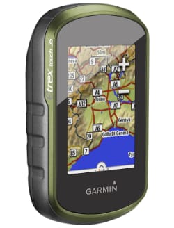
1. Garmin GPSMAP 64sx
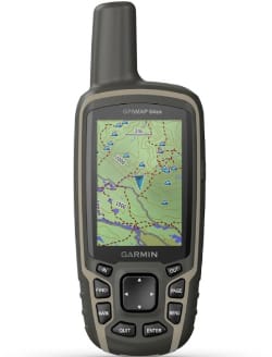
This Garmin handheld GPS combines features and reliability to be the best overall choice. The Garmin GPSMAP 64sx measures 2.4” x 6.3” x 1.4” and has a 1.43” x 2.15” display with a 160 x 240 pixel resolution. It has a 3-axis compass, barometric altimeter, and multi-GNSS support which includes GPS, Galileo, and GLONASS. In GPS mode you’ll get up to 16 hours of battery life. You can share your routes, geocaches, tracks, and waypoints wirelessly with your friends, plus this model has an IPX-7 waterproof rating. It includes 8 GB of memory and has external storage for a microSD™ card up to 32 GB. The Garmin GPSMAP 64sx is a perfect option whether you’re going climbing, cycling, geocaching, or hiking.
Best Budget Handheld GPS
2. Garmin eTrex 22x/32x
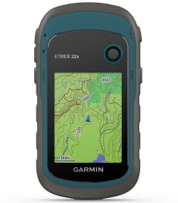
If budget is an issue but you don’t want to sacrifice quality, then go with the Garmin eTrex 22x. It supports the GPS and GLONASS satellite systems and is preloaded with TopoActive maps. It has 8 GB of internal memory and a slot for a microSD™ card up to 32 GB. It’s geocache-friendly, has a hunting/fishing calendar, has sun and moon information, and holds 2,000 waypoints and 200 routes. You’ll get up to 25 hours of battery life with 2 AA batteries and it has a waterproof rating of IPX-7. While it doesn’t have a barometric altimeter or a 3-axis compass, you can upgrade to the Garmin eTrex 32x if you’d like those features. Both models weigh 5 ounces, measure 2.1” x 4” x 1.3”, and have a screen size of 1.4” x 1.7” with a 240 x 320 pixel resolution. The Garmin eTrex 22x is an ideal budget-friendly backpackers’ GPS.
Best Hybrid GPS/Satellite Messenger
3. Garmin inReach Explorer+
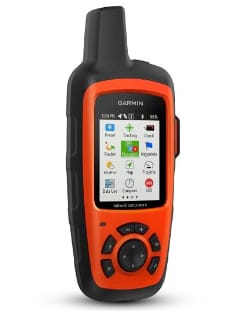
For those who love backcountry adventures but don’t want to worry their family and friends, this is the best hiking handheld GPS. Thanks to the Iridium® satellite network two-way text messaging is enabled and you’re able to trigger an interactive S.O.S. to the 24/7 search and rescue monitoring center. This GPS pairs with compatible mobile devices and allows you to share your location. You can get up to 100 hours from the rechargeable lithium-ion battery in default mode and up to 30 days of battery life when it’s in power save mode. It’s IPX-7 waterproof rated and has a barometric altimeter and 3-axis compass. This Garmin measures 2.7” x 6.5” x 1.5”, weighs 7.5 ounces, and has a 1.4” x 1.9” screen with a 200 x 265 pixel resolution. If rugged adventures off the grid are your type of fun, bring along the Garmin inReach Explorer+.
Best GPS for Paperless Geocaching
4. Garmin eTrex 10
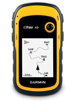
Leave the paper maps at home and go on your geocaching trips with the Garmin eTrex 10. The user interface has been improved, and a worldwide basemap is included. The GPS and GLONASS satellites are combined with a WAAS-enabled GPS receiver and HotFix® satellite prediction to find your location quicker, even if trees or a deep valley are impacting the signal. The 5-ounce GPS was built to resist dust, dirt, humidity, and water, and has an IPX-7 waterproof rating. It has 6 MB of memory and you can get up to 25 hours of battery life before having to change the AA batteries. This GPS measures 2.1” x 4” x 1.3” and has a screen size of 1.4” x 1.7” with a 128 x 160 pixel resolution. Once you get your Garmin eTrex 10 you’ll be ready to start searching for caches.
Best Handheld GPS With Touchscreen
5. Garmin Oregon 700
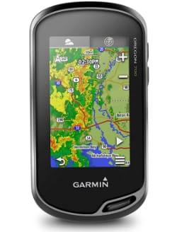
Hunting with a GPS is easier if it has a touchscreen because it’s more responsive and more intuitive than a GPS with buttons. Whether you’re hunting, fishing, or hiking, you’ll appreciate having the Garmin Oregon 700 with you. It has dual GPS and GLONASS satellite reception and its redesigned antenna improves reception and performance. Along with the 3-axis compass it also has accelerometer and barometric altimeter sensors. The touchscreen has a resolution of 240 x 400 pixels and measures 1.5” x 2.5” while the GPS itself measures 2.4” x 4.5” x 1.3”. It supports Geocaching Live, Active Weather, Bluetooth-enabled smart notifications, and automatic uploads to Garmin Connect™. It offers up to 16 hours of battery life and an IPX-7 waterproof rating. For a premium touchscreen GPS, consider the Garmin Oregon 700.
Best of the Rest
6. Garmin GPSMAP 66i
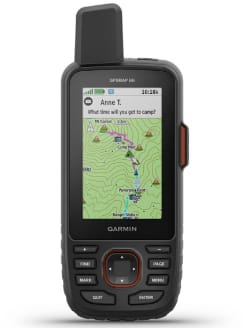
The Garmin GPSMAP 66i was built for adventure and created with military standards for thermal, shock, and water performance. You can see the 1.5” x 2.5” screen in any light conditions and it’s compatible with night vision goggles. It uses GPS and Galileo, and it has sensors for an altimeter, barometer, and 3-axis electronic compass. This is a great GPS for backpacking wherever you’d like since InReach and Iridium® allow you to communicate and exchange text messages without having to rely on cell phone coverage. You can track your location and send an S.O.S. message to a 24/7 response center in the event of an emergency. In power mode you can get up to 200 hours of battery life and in default mode you can get up to 35 hours of battery life with your location being tracked every 10 minutes. The GPS measures 2.5” x 6.4” x 1.4”, has a display resolution of 240 x 400 pixels, and weighs 8.1 ounces. With the Garmin GPSMAP 66i you can be confident you’ll be able to stay in contact no matter where the trail takes you.
7. Garmin Montana 680
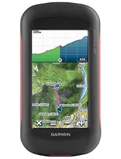
If you want to take pictures along the way but don’t want to bring your point-and-shoot camera, check out the Garmin Montana 680. This glove-friendly touchscreen GPS boasts an 8 megapixel autofocus camera that automatically geotags photos. It supports both GPS and GLONASS satellites, is a WAAS-enabled receiver, and is equipped with HotFix® satellite prediction. It also has a barometric altimeter and a 3-axis compass. It has 4 GB of memory and you can add additional maps on a microSD™ card. It allows you to share your geocaches, waypoints, routes, and tracks wirelessly with other compatible Garmin GPS users. The IPX-7 rated GPS measures 2.9” x 5.7” x 1.4”, has a display size of 2” x 3.5”, and a display resolution of 272 x 480 pixels. Whether you’re looking for a hiking, biking, or mountaineering GPS, the Garmin Montana 680 is a great companion.
8. Magellan eXplorist 310
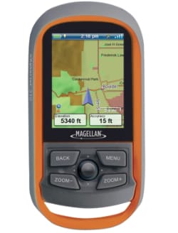
One of the best hiking GPS units is the Magellan eXplorist 310. It weighs 5.2 ounces, measures 5.6” x 5.8” x 2.4”, and has a screen size of 2.2”. Thanks to WAAS, EGNOS, and MSAS (a Japanese-based satellite system) it provides accuracy up to 3 meters. This Magellan gives you 18 hours of battery life and an IPX-7 waterproof rating. Included is a detailed road network, water features, realistic shading, and much more. Plus, you’ll have 500 MB of memory available to store topo maps, geocaches, tracks, and waypoints. The Magellan eXplorist 310 was designed to be durable and last for years to come.
9. Garmin eTrex Touch 35
Whether your adventures include geocaching, kayaking, cycling, or hiking with a GPS, the Garmin eTrex Touch 35 has what you need. It locates you fast thanks to the GPS and GLONASS satellites. It has 250,000 preloaded geocaches and 4 GB of memory to hold more maps. This GPS is equipped with a lot of the features you’d expect like a barometric altimeter, 3-axis compass, and wireless connectivity. It measures 2.3” x 4” x 1.3”, weighs 5.6 ounces, has a 1.43” x 2.15” display, and has a display resolution of 160 x 240 pixels. The Garmin eTrex Touch 35 was designed to simplify all of your outdoor adventures.
10. Garmin Foretrex 601
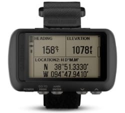
For those who want to be hands free, leave your outdoor watch at home and instead wear the wrist-mounted Garmin Foretrex 601. This Garmin is great for fishing and is one of the best hunting GPS units since it’s not handheld. It was constructed to military standards and has a battery life that can exceed 48 hours. Smart notifications allow you to receive alerts, emails, and texts without checking your phone, and the Garmin Connect™ Mobile app (iOS/Android) allows others to follow your route. It’s easily able to track your location in challenging environments thanks to the collaboration of GPS, Galileo, and GLONASS. Even though it’s wrist-mounted, the GPS still has wireless connectivity, a 3-axis compass, and a barometric altimeter. If you’ve been in the market for the best handheld GPS for hunters or hikers, consider something different and try out the Garmin Foretrex 601.
Whether you need to find your bearings in a whiteout, in the backcountry, or in open water, any of the above GPS devices will have you covered. Not only that, but many of them have several additional features that can make your outdoor adventures even more convenient and more enjoyable. If you agree that it’s better to be safe than sorry, a handheld GPS is a must.


Comments